2025 жылдың желтоқсан айының ортасында "Қазақстан Республикасының Қызыл Ай қоғамы" ҚБ "Халықаралық Қызыл Крест және Қызыл Ай қозғалысының негізгі қағи әрі қарай оқу
Сөздәйектер галереясы
Ғылым білімге қонады; ғылымсыз білім тым құрғақ.
Жүсіпбек Аймауытов
Факультеттер жаңалықтары
2025 жылғы 26 желтоқсанда тарих, экономика және құқық факультетінде өткен оқу жылының қорытындысын шығаруға арналған факультет кеңесінің қорытынды оты әрі қарай оқу
17.12.2025 на медицинском факультете НАО СКУ им.М.Козыбаева началась экзаменационная сессия. С целью укрепление принципов академической честности, про әрі қарай оқу
12 декабря 2025 года, в рамках реализации плана научных мероприятий медицинского факультета на 2025–2026 годы, был проведён практический семинар с гру әрі қарай оқу
2025 жылдың 2 желтоқсанында Солтүстік Қазақстан облысының Әділет департаменті "Заң және тәртіп" идеологиясын жүзеге асыру аясында студенттерге дәріс ө әрі қарай оқу
ТЭжҚФ-те АИ көмегімен шешімдерді жеделдету бойынша семинар өтті 2025 жылғы 27 қарашада тарих, экономика және құқық факультетінде бизнес-кеңесші және әрі қарай оқу
На факультете прошёл круглый стол со студентами 5 курса фармацевтического профиля на тему «Надлежащие аптечные практики: цели, задачи и подходы к реал әрі қарай оқу
2025 жылғы 12 қарашадан бастап М.Қозыбаев атындағы СҚУ медицина факультетінде визитинг-профессор, кәсіптік Милан университетінен Claudio Colosio медиц әрі қарай оқу
19.11.2025 жылы медицина факультетінде «Манаш Қозыбаевтың ғылыми және адамгершілік ұстанымы ретінде патриотизм» атты дөңгелек үстел өткізілді. Қатысу әрі қарай оқу
Круглый стол «Роль Манаша Козыбаева в развитии гуманитарного образования в Казахстане», посвящённый дню рождения выдающегося казахстанского учёного-гу әрі қарай оқу
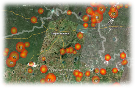
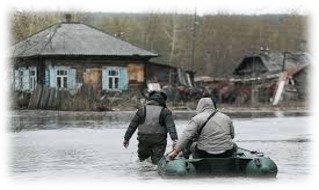
Солтүстік Қазақстан облысында Жерді қашықтықтан зондтау деректері негізінде толық масштабты модель құру арқылы су тасқыны жағдайының дамуын модельдеу
Басым бағыт: ақпараттық, телекоммуникациялық және ғарыштық технологиялар, жаратылыстану ғылымдары саласындағы ғылыми зерттеулер
Жоба жетекшісі: Сартин С.А., ф.-м.ғ.к.
Жобаны орындаушылар: Рудер В.П., магистр, Щукина В.Н., магистр, Фомин И.А., магистр, Пономаренко А.С., магистр.
Орындау мерзімі: 2018-2020 жж.
Қаржыландыру көлемі: 94 200 000 теңге.
Жобаның мақсаты: жоғары кеңістіктік рұқсатпен Жерді қашықтықтан зондтау (аэрофототүсірілім арқылы) деректерін алу және оларды геоақпараттық жүйелер (ГАЖ) көмегімен өңдеу. Қар жамылғысының қалыңдығын автоматты түрде анықтау үшін сенсорды әзірлеу және сынау.
Күтілетін нәтижелер: Есіл өзенінде көктемгі су тасқыны болжамының математикалық моделін әзірлеу, ол 1-2 метр дәлдікпен елді мекендердің маңындағы судың көтерілу деңгейінің болжамын қамтамасыз етеді, су басуы ықтимал аймақтарды модельдеуге, су басқан аумақтарды су басу процестерінің динамикасын бақылауға, су басқан аудандарды пилотсыз ұшу аппараты арқылы бағалауға мүмкіндік береді. Осы жобаны іске асыру су жайылмалық рельефтің 3D моделін алуға және үнемі нақтылауға мүмкіндік береді.
Жобаның сипаттамасы: қазіргі уақытта заманауи геодезиялық жабдықтарды, сондай-ақ ұшқышсыз ұшу аппаратын (ҰҰА) қолдана отырып, Жерді қашықтықтан зондтау саласында жұмыстар белсенді жүргізілуде. Есіл (Ишим) өзені жайылмасының топографиялық түсірілімін, Есіл (Ишим) өзені бассейніндегі қар жамылғысының тереңдігі және алты сәулелі эхолоттың көмегімен алынған су түбінің бейіндері туралы деректерді пайдалана отырып, елді мекендер маңында Есіл (Ишим) өзенінің төгілуінің және олардың су басу деңгейінің толық масштабты моделін жасау жоспарлануда. Сергеевка және Петропавл қалалары арасында су тасқыны жағдайын дамыту моделін әзірлеу. Модельде Есіл өзенінің бассейніндегі қар жамылғысының жай-күйі туралы жаңадан келіп түскен деректерді ескере отырып, жедел түзету көзделетін болады.
Жобаның міндеттері:
−Есіл өзенінің жайылмасы туралы жоғары дәлдікті геодезиялық деректерді алу;
−Есіл өзені арнасының жай-күйі туралы деректер алу;
−Есіл өзені бассейніндегі қар жамылғысының жай-күйі туралы деректерді қашықтықтан алу әдістерін әзірлеу және іске асыру;
−Есіл өзенінің арнасы бойынша еріген сулардың өту моделін құру;
−деректерді визуализациялау және су тасқыны жағдайының дамуын көрсету үшін компьютерлік модель жасау;
−су басу аймағын көрсететін компьютерлік модельді алу.